©pixabay.com/Dolcevia
How can the cultural relevance of a region, or even an entire country, be measured? Experts and laypeople alike have been arguing about this for centuries. The UNESCO list of World Heritage Sites at least gives an indication, and Italy plays a central role there. The 60th site was given this special honour in 2024, and it is one with special historical significance. ‘Via Appia. Regina Viarum’ encapsulates the unique Roman road that originally connected Rome with Capua and Brindisi as well as the Via Traiana, leading from Benevento to Brindisi, along 22 stages in four regions. We share what made the Via Appia so important, what the nickname ‘Regina Viarum’ is all about and what there is to admire along the road.
The revolution in road construction
The Roman Empire grew rapidly and expanded from a local power to a Great Power within a comparatively short period of time. It needed fortified, direct connections to key locations in order to reach all corners of this growing dominion. The construction of the first Roman Road, the Via Appia, began under the consul Appius Claudius Caecus in 312 BC. Originally, it connected the capital Rome with Capua and was intended to facilitate military supplies before it was connected with Brindisi, a harbour town in what is now Apulia in the far south of Italy, around 190 BC, along its current length of 540 km. It was deservedly given the nickname ‘Regina Viarum’, or ‘Queen of the Road’, in ancient times, which goes back to the Roman poet Publius Papinius Statius during the 1st century AD.
Compared to the unpaved natural paths that prevailed at the time and whose routeing depended on geological and topographical conditions, the Roman roads that ultimately encompassed a network of 80,000 to 100,000 kilometres were much more similar to today’s roads. The ground was secured by an excavation of around one metre before layers of coarse stones, gravel and sand provided stability until the road surface, consisting of cobblestones and framed by kerbstones, was laid.
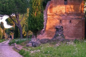
The decline of the Via Appia itself began in late antiquity, when the Pontine Plain south-east of Rome began to become marshy. Today’s arterial road was built at the end of the 18th century and became more important when the marshes were drained in the 1930s. Today, as the SS 7 Via Appia, it is a state road and largely follows the original route. And yet you can still see at least parts of the ancient road in many stages, especially in Rome, where tombs and catacombs once lined the route. Some of them can still be visited today.
From Rome to Brindisi in 18 stages
The original route of the Via Appia from Rome to Brindisi not only brings together centuries, even millennia of road and urban construction, but also leads through an exciting landscape in the south of Italy that certainly deserves more attention. We follow the 18 stages of the UNESCO World Heritage Site through a total of four regions and introduce you to several highlights along the way.
Via Appia in Lazio
The world-famous Roman road begins in Rome, in the heart of Lazio, and slowly heads south. Half of all stations are located in this region, and with good reason:
- Stage 1: A gate supposedly once located on today’s Piazza di Porta Capena in Rome is the starting point of the Via Appia. Along the first approx. 21 kilometres you move through the south-east of Rome. You will pass the Baths of Caracalla as well as numerous large tombs and catacombs on your way out of the city.
- Stage 2: The Alban Hills, the remains of a former volcanic mountain range, make up the next stage. You reach the pleasant town of Albano Laziale with the remains of the old Roman legionary camp Castra Albana, ancient thermal baths and a largely decayed amphitheatre. A viaduct takes you to the third stage.
- Stage 3: On the 19th to 24th mile, as this stage is officially called, you set your sights on the ancient village of Lanuvium. The detour to modern-day Lanuvio is dedicated to the imposing sanctuary of Santuario di Giunone Sospita with its huge colonnade before returning to the Pontine Plain.
- Stage 4: A detour to the ancient city of Norba, which was destroyed by a firestorm, not far from modern-day Norma is a must. The roads which have been extensively excavated since 2011 lead you through an active archaeological site. According to legend, Cyclops or Hercules founded the city and arranged the massive stones of the main gate.
- Stage 5: Another ancient city is the focus of this stage. The former Roman civil colony of Tarracina, not far from modern-day Terracina, can be reached via various bridges and gates. Remains of old buildings were incorporated into later structures, such as the Porta Romana or the Foro Emiliano.
- Stage 6: Fundi (today: Fondi) was probably founded by the Aurunci and only taken over by the Romans in later years. The massive city wall, which today frames the Via Appia, survived heavy bombing raids and frames spectacular towers and the imposing Portella gate.
- Stage 7: One of the most scenic stages of the Via Appia leads over the Monti Aurunci through the nature park of the same name. The Roman road winds its way through gorges and tight hairpin bends, reaches gradients of up to 9.8 % and takes you past ancient sanctuaries and massive walls of old water reservoirs towards Itri.
- Stage 8: After this challenge the route continues from mile 83 to Formiae via long, flat sections towards the sea, past the towering Tomba di Cicerone. Massive towers and a fountain from Roman times that once quenched the thirst of travellers welcome you in today’s Formia. The next stage continues via Castellone.
- Stage 9: The route from Lazio to Campania is dedicated to the former Roman colony of Minturnae whose original military orientation can be clearly seen from the walls. You will be able recognise the traces of old waggons on the more modern stages of the Via Appia.
©Bigstock.com/DinoPh
Via Appia in Campania
The tour continues to the Campania region, best known for its capital Naples and the active volcano Vesuvius. The most densely populated region in Italy is home to four stages of the World Heritage Site:
- Stage 10: The route continues along a long, flat stretch of coastline before heading inland at Monte Massico. The first stop is Sinuessa. The few surviving remains of the amphitheatre, the walls and the aqueduct are reminiscent of Roman times. Pagus Sarclanus, a huge Roman complex, leads to the next destination.
- Stage 11: The region of present-day Capua, populated as early as the 9th century BC, still bears the traces of Roman triumphs today. Here you will find the remains of the second largest amphitheatre in the Roman Empire and the triumphal arch in honour of Emperor Hadrian. An extremely rare, well-preserved Mithraeum awaits you in the city centre.
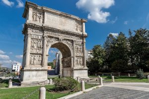
- Stage 12: We are now approaching Benevento, the former Beneventum and original destination of the first Via Appia. Here stands the world-famous Trajan’s Arch whose reliefs depict a complete political programme. Another ruined amphitheatre and the monumental Arco del Sacramento are among the highlights.
- Stage 13: Now we set off for the Basilicata region and set our sights on Aeclanum. Before doing so, stop by Nuceriola where travellers once rested. The pillars of the destroyed Ponte Rotto, which still tower into the sky, are witnesses to days long gone. At the Aeclanum archaeological site you can see the remains of the ancient walls and city structures.
Via Appia in Basilicata
One of the most sparsely populated regions in Italy becomes the segue to the end of the road. Just one stage is located in Basilicata and leads straight on to Apulia:
- Stage 14: The Via Appia runs through the Upper Bradano Valley between towering slopes and wide fields. This area was already being predominantly used for agriculture in Roman times. Venosa with its archaeological park is a must-see, especially the ancient Abbazia della Santissima Trinità.
Via Appia in Apulia
The final leg of this great journey is Apulia, the south-easternmost region of Italy which forms the ‘heel’ of the country. You will find the last four stops on the way to Brindisi:
- Stage 15: Numerous wagon tracks lead you along a former ‘sheep track’ through the middle of another scenic section. You will see traces of the old road and former smaller rest stops not far from the modern-day town of Altamura.
- Stage 16: Taranto, originally a Greek colony is another important city on the itinerary. Time and time again you will come across the remains of the former Taranto, such as the columns of the Tempo Dorico or the actual Via Appia Antica that was hardened with gravel. Further highlights can be seen in the National Archaeological Museum.
- Stage 17: The old Roman road now continues on its way to the Adriatic coast and leads past the former Mesochorum rest stop. Around Oria you will see the remains of various branches of the Via Appia that, among other things, lead to the town of Urbius, originally founded by the Messapians. At the Scamnum rest stop you already have your destination in sight.
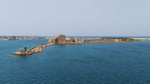
- Stage 18: The Roman colony of Briundisium was founded around 244 BC in order to open up the natural harbour. Today’s Brindisi became a strategically important part of the Roman Empire. Various archaeological sites, such as Pietro degli Schiavoni, and the mighty Roman columns at the end of the Via Appia bear witness to this.
©pixabay.com/Eleatell
The four stages of the Via Traiana
Wait a minute, wasn’t there originally talk of 22 stages? We actually left out four of them … until now. They are part of the Via Traiana that branches off from the Via Appia at stage 12 in Benevento and also leads to Brindisi. It was built around 109 BC at the behest of Emperor Trajan when the Via Appia had lost its importance due to a period of military calm and, on top of that, managed to reach its destination a day faster than the original Roman road. Several highlights await you along the coast:
- Stage 19: The Via Traiana originally began shortly after Trajan’s Arch and led over the Ponte Valentino towards Apulia without any detours. Not far from Buonalbergo is the Ponte delle Chianche, one of the best-preserved bridges along the road. However, some of the old landmarks of the Via Traiana have been removed for building purposes, including the church of Santa Maria dei Bossi in Casalbore.
- Stage 20: The small town of Troia was built on the ruins of the ancient settlement of Aecae. We head into the open countryside after a short tour. Kilometres of seemingly endless fields accompany the Via Traiana southwards. Ancient bridges and aqueducts line the route to Herdonia.
- Stage 21: A 170-metre-long bridge with five massive arches crosses the River Ofanto and heads towards the small town of Canosa di Puglia, once the site of an ancient Greek settlement. A large cemetery complex that dates back to pre-Roman times lines the route. The overgrown Arco di Varrone is another highlight before the archaeological excavation site at Barletta reveals an impressive cittadella.
- Stage 22: Finally, you head for the Apulian capital of Bari and continue south along the coast. Here, too, you will discover deep furrows of old wagons and be enchanted by the Abbey of San Stefano near Monopoli as well as the giganticdimensions of the ancient city of Egnatia. Remains of ancient sanctuaries and early Christian churches line the route to your destination in Brindisi.

©pixabay.com
The seemingly endless Via Appia and the somewhat smaller, equally exciting Via Traiana were of crucial importance for the development of the Roman Empire. Looking for ancient traces, you will discover old parts of the road and their remnants, exciting villages and fascinating archaeological sites that grant you impressive insights into life two thousand years ago and more. As a welcome side effect, you get to see more of the unjustly overlooked south of Italy and discover many a beautiful place while visiting the various areas of the Regina Viarum. This extensive UNESCO World Heritage Site is sure to capture your imagination.